• Discover new ways to elevate your game with the updated DGCourseReview app!
    It's entirely free and enhanced with features shaped by user feedback to ensure your best experience on the course. (App Store or Google Play)

New Park Map

PA_Disc

Par Member
Joined
Jan 28, 2008
Messages
198
Location
Green Lane, PA
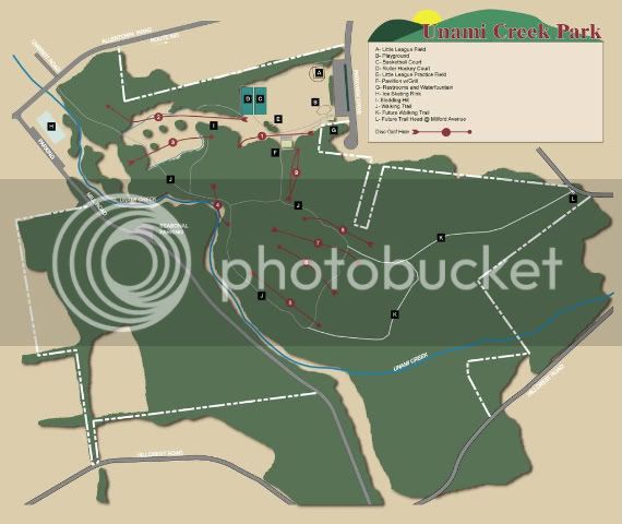
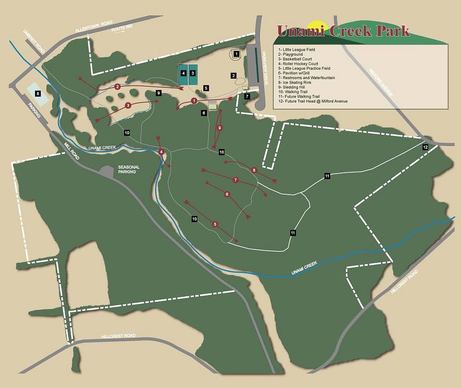
Here is a new park map that I drew up for our new course(see thread for new course signs). Let me know what you think. Any ideas on additions or alterations would be appreciated. Thanks.

COURSEMAP.jpg
 
Awesome Map derF! I think this would be a great sign at the start of the course, but I think you definitely should have a downloadable Black and White version so people can print them out at home...

Any updates on the course? Post them elsewhere...;)
 
Thanks. I plan on having the park map in a message center at the start of the course as you said. I need to add a "You are here" dot. Thanks for reminding me.

Not a whole lot to update on the course. Most of all the clearing is complete, the tee box frames are in, the signs are drawn up... I will be ordering cement today so I can start installing the sleeves sometime soon. Our next(last) work day is set for the 26th of July. Im hoping that I may have the majority of the work complete and that the 26th can be mostly cleanup work. I was out yesterday to do more weedwacking and trimming. I also found a spot for the practice basket and cleared that some...
 
That looks really cool. I agree with the downloadable map suggestion, which I am sure you were going to do/have anyways. I'm excited to have this course. I'm only about an hour away, so looking forward to trying it out.

What program did you use to make the map?
 
Last edited:
Thanks for the kind words. I put the map together using Illustrator. I never reeally used the program before, but I am familiar with Photoshop so many of the functions are similar.
 
The map looks great. I like the little "arrow feathers" on the ends that show the direction of the holes. The white dotted borders show up well.

I'd get rid of the square black numbers 1-12 because they can easily be confused with hole numbers. When I first glanced at it I thought that #10 was a humongous long hole (until I saw the legend). Most of those items don't really matter to DGers anyway.

With maps you want to keep it clear and as simple as possible. You might include some dotted lines in yellow to show the trails to the next tee on long walks.

Keep in mind that players mainly only consult a map when it's not obvious where to go to the next tee, or if they can't see the basket and want to know how the hole plays. If you can take a relatively inexperienced player out with you to walk the course then note the points they need clarification on where to go and make sure those are REALLY clear on your map.

Hope this helps...
 
More thoughts...

  • All the dark colors will take a lot of ink to print. Can you make the area smaller so that it only covers the part of the park with the course in it?
  • The park name is a little hard to read with the background behind it. It's a little too busy.
 
Here's the best map I've ever seen.
New Quarter Park in Williamsburg VA.
Printed on card stock. Clear, simple, graphically appealing.
 
Thanks for the feedback. The thing is with this map is its use will be for everyone who uses the park, not just DG'ers. So I will leave the legend of the various park ammenities on this map. I do agree about the #'s being confusing and I have already changed them to letters to avoid any confusion. The colors that I used on this map are consistant with the tee signage I posted previously. I will make a reduced size map that will be available online in a grey scale(Blk/Wt).

I am already working on a score card that will have the hole layouts on it that will be just for the DG'ers.
 
Here's the best map I've ever seen.
New Quarter Park in Williamsburg VA.
Printed on card stock. Clear, simple, graphically appealing.

Simple but very easy to see and use. That is great Olorin.

Can't wait to see you finished product PA_Disc. I agree with Olorin, you really need to adjust the park name to make it easy to read. Maybe a black outline just outside your white outline should do it. Great job.
 
I agree with Olorin, you really need to adjust the park name to make it easy to read. Maybe a black outline just outside your white outline should do it. Great job.

Or, for the name, you could...
1) Put the name inside the legend box
2) Get rid of the distracting background, e.g.- the hills, sun, and road.

Once again, these are minor tweaks, and coming from a perfectionist.

P.S.- It's always nice to be agreed with! Thanks Donovan.
 
*Revised*

Green Lane is south of Allentown about 25 miles and North of Philadelphia about 35miles.

Here is a revised copy of the Park Map. I think I covered everything?

COURSEMAP_062708.jpg
 
I hate to say it, but the name is still difficult to read. Otherwise, great job!
 
Top