• Discover new ways to elevate your game with the updated DGCourseReview app!
    It's entirely free and enhanced with features shaped by user feedback to ensure your best experience on the course. (App Store or Google Play)

'Then And Now' (old historic photos of your course)

LeewayeDiscGolf

Double Eagle Member
Joined
Oct 16, 2009
Messages
1,375
Location
Pueblo, Colorado
This thread is for old historical photos or videos of what your course used to look like a long time ago. I'm talking 50 + years ago or what the land was before the course existed. I recently came across a few old pics of our course, and my wife and I retook the photos from the same places in the present time. I personally love old historic photos and seeing what places and landmarks looked like years ago. It's my hope that others do too, and that we can get some really awesome 'then and now' photos in this thread.

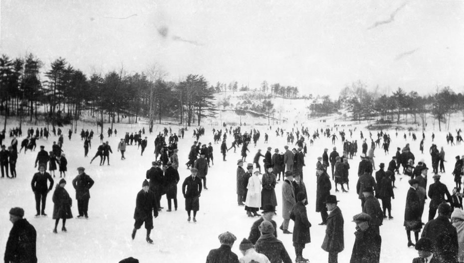
The first pic is the old 'Rock Garden' in Pueblo City Park back in the early '30s.
Not many trees and not much grass. Just the bridge and the 'Rock Garden'.
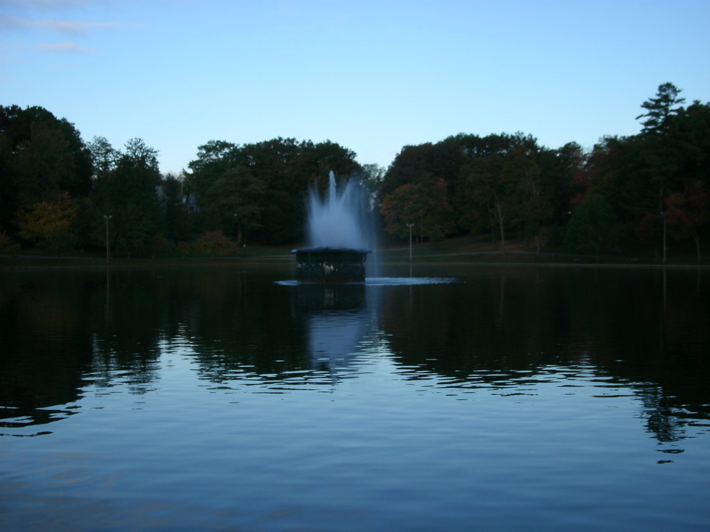
The second pic is taken from the same spot on Nov. 9th, 2012. This is currently the 18th hole of Pueblo City Park Disc Golf Course. You can see that there are now tons of trees and some grass. The bridge is still standing and structurally sound. There are also still some original 'Rock Garden' rocks remaining.
 

Attachments

  • 197122_3881776963353_621201344_n.jpg
    197122_3881776963353_621201344_n.jpg
    150.4 KB · Views: 163
  • 521754_3881775363313_1681401805_n.jpg
    521754_3881775363313_1681401805_n.jpg
    82.4 KB · Views: 182
The first photo is from the early '30s of what was then called 'The One Way Lakes'. You can see the bridge once again and notice there is no terraced-wall along the left of the photo.
The second pic is taken from the same spot on Nov. 9th, 2012. This is currently the 17th hole of Pueblo City Park Disc Golf Course. The lakes are now gone, replaced by 17s fairway. Terraced-walls have been built along the left of the photo. And the bridge remains. Trees once again dominate the new photo.
 

Attachments

  • 557792_3881771923227_419470391_n.jpg
    557792_3881771923227_419470391_n.jpg
    65.3 KB · Views: 102
  • 394976_3881774883301_1788977384_n.jpg
    394976_3881774883301_1788977384_n.jpg
    151 KB · Views: 100
The first photo is a pic taken of a picture hanging in our local library of the previously mentioned bridge. Notice the heavy forest.
The second photo is taken from the same spot on Nov. 11th, 2012. The photographer would basically be standing on 17's close, left placement, which is unuseable at the moment due to a broken lock tab. The heavy forest has thinned considerably and there is now a swamp under and near the bridge.
 

Attachments

  • 550178_3892770118175_832775197_n.jpg
    550178_3892770118175_832775197_n.jpg
    123.1 KB · Views: 90
  • 402418_3892767758116_1956423861_n.jpg
    402418_3892767758116_1956423861_n.jpg
    124.3 KB · Views: 92
Schenley Park used to have a horse track up where the running track and soccer fields are now. Some of the foundations for the grandstands are still there and there is an elevated basket on one of them for hole 15. The picture below says that the picture is from the opposite side of the track, but I would assume that the grandstands would be on either side of the track.

012611oval.jpg


98424482.jpg
 
The first photo is an old historic photo of a statue dedication at what is now called CSU Pueblo. I'm not sure what the statue is or what it is celebrating, but we are trying to find out. This is right next to the middle of what is now Hole #1.

The second photo is from Feb. 8th, 2013 and taken from the same spot as the original pic. The same statue uncovered and now surrounded by a tree.
 

Attachments

  • IMAG5033.jpg
    IMAG5033.jpg
    46.4 KB · Views: 64
  • IMAG5066.jpg
    IMAG5066.jpg
    154.3 KB · Views: 65
The first photo is the library at CSU Pueblo.

The second photo is taken from the same spot on Feb. 8th, 2013. Hole #1 now plays across the front of the library from left to right.
 

Attachments

  • IMAG5034.jpg
    IMAG5034.jpg
    137.4 KB · Views: 56
  • IMAG5065.jpg
    IMAG5065.jpg
    78.7 KB · Views: 55
Last edited:
The first photo is the Belmont Resident Hall on the right and the gym on the left at what is now CSU Pueblo.

The second photo is taken from the same general spot as the first on Feb. 8th, 2013. There are now massive bushes along the gym and huge trees on the corner of the hall. The 18th Hole tees from the left of the gym to the basket, which can be seen on the right corner of the hall.
 

Attachments

  • IMAG5031.jpg
    IMAG5031.jpg
    70.4 KB · Views: 41
  • IMAG5068.jpg
    IMAG5068.jpg
    144.8 KB · Views: 39
This is by far, in my opinion, the coolest pic of the CSU set.

The first photo is from 1966 during the building of the Belmont Resident Hall at what is now called CSU Pueblo. Just the steel frame is up and a huge crane is seen.

The second photo is taken from the same spot as the original on Feb. 8th, 2013. The pic is taken from what is now the far left of 18's fairway. The hall has been completed for many years and is surrounded by multiple trees and grass. The basket for Hole 18 is in the trees at the corner of the hall.
 

Attachments

  • IMAG5028.jpg
    IMAG5028.jpg
    109.3 KB · Views: 55
  • IMAG5070.jpg
    IMAG5070.jpg
    85 KB · Views: 58
Another very cool pic in my opinion.

The first photo is an aerial shot of Pueblo City Park. A building can be seen in the field and a lake/river runs through the park.

The second photo was taken by Google Earth and is of the same area of Pueblo City Park. The current Hole 16 plays from the bottom left of the photo upwards. All that remains of the building in the field is some foundations peeking through the grass about midway on 16's fairway. The lake/river is long gone and is now the 17th Hole. A small swamp/creek still runs along the path of the original lake/river and forms the left side OB on Hole 17.
 

Attachments

  • IMAG5035.jpg
    IMAG5035.jpg
    115.3 KB · Views: 48
  • 542635_4351168057837_183355366_n.jpg
    542635_4351168057837_183355366_n.jpg
    68 KB · Views: 45
Central Park in Schenectady, NY. Just did a quick google search and found the following:

From 1916 - skating on the lake in the winter
ice_skaters_Schenectady_Central_Park_1916_Grems_Doolittle.jpg


Present - I believe this is about the same perspective - trees have filled in the empty hillside beyond the lake and some houses were built up on top behind it - fountain now in the middle of the lake. Hole #15 plays down the hill through the trees just to the right of the fountain (as seen in the picture - "beyond" the walking path) then back up slightly to the pin perched behind the trees that appear to the left of the fountain (as seen in the picture). Hole #16 plays from right next to the light post seen just to the left of the fountain, back towards the hill on the right, across the walking path and up into the trees.

5095202374_98acd0cb08_b.jpg
 
North Valley Park - First winter in 1990 - Original hole 1 similar to playing from short tee on current hole 18 at The Valley DGC.
 
Last edited:
Here are some aerial snapshots of Holes 4, 5, and 6 of Carey Park taken from Google Earth.

Wish I could've played the course when there all those additional pine trees!

479842_10151261331011315_1394756804_n.jpg
 
Wish I could've played the course when there all those additional pine trees!
Here's a photo of Hole 5 from 2003, before they were planted.

67sex0.jpg


If my memory is correct, those were installed around late 2004. They really tightened that hole up and would have turned that into an epic shot had they grown to maturity. When we had the flooding in the Spring of 2007 and couldn't play the front nine for almost three months, that's what did them in.

Then, the following December, we had the ice storm, which reeked havoc on the hardwood trees. Here's the hole that breaks my heart, Hole #16.

2003...

wivqer.jpg


and 2011...

d33d16ae.jpg


Granted, due to that tree by the road being gone now, I've aced this hole twice, so there's always a silver lining.
:p
 
Wow! Hole 16 looked like a beautiful shot back in that old photo! Do you have more historical photos of the course?? I'd love to take a look at some of the old course before I started playing a lot out there (pre-2007).

If you happen to come across any, you can email them to me at: [email protected]
 
Wow! Hole 16 looked like a beautiful shot back in that old photo! Do you have more historical photos of the course??
Those pics to my memory were taken in August 2003, not long after I started playing. Back in the day there wasn't a whole lot of DG information about, and being somewhat interested in web design, I was actually trying to build a local version of DGCR that would showcase photos and maps of existing courses.

I of course was in way over my head, and that project never off the ground. Thankfully, someone came along and not only did it much better, but got the entire world involved.

But while cleaning up the apartment, I happened to find an old photo CD that had those on there. I'm still trying to locate some others that showed when the pine trees were in place.

My plans are to re-shoot the course this Summer when the foliage grows in and show the difference after 10 years.
 
Top