• Discover new ways to elevate your game with the updated DGCourseReview app!
    It's entirely free and enhanced with features shaped by user feedback to ensure your best experience on the course. (App Store or Google Play)

Phone Based Maps

HyzerUniBomber

* Ace Member *
Joined
Sep 9, 2013
Messages
2,036
Location
Denver, CO
I'm sure that folks have been in this situation - I certainly have - where you want to play a new course. Check the dgcr reviews, it's got enough *'s to get the blood pumping and then show up and find that:

  1. The map online sucks
  2. The map at the course sucks
  3. The map doesn't exist
  4. There's nobody around to show you the course
  5. You just played hole 1, 5 and then 18 because it's confusing.

I thought if there was an easy way to download some standard phone friendly sized maps that you can flip through your phones photo viewer? It could be made web friendly obviously - but waiting for the next map to DL when you're out in a spot that doesn't have a reception would not be great.

6cljvs7.gif


uBZj7Yp.gif


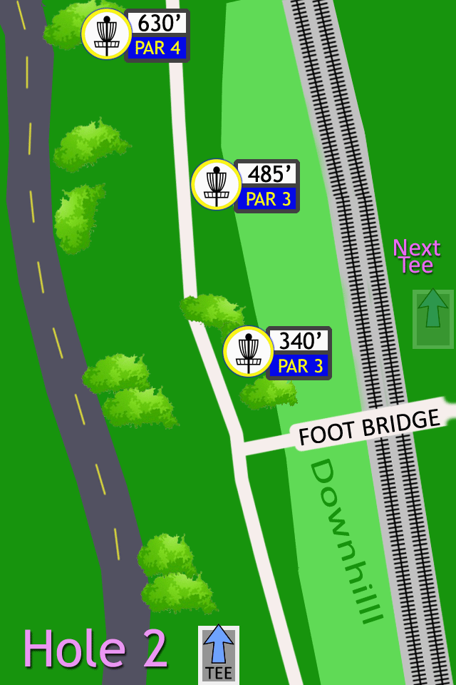
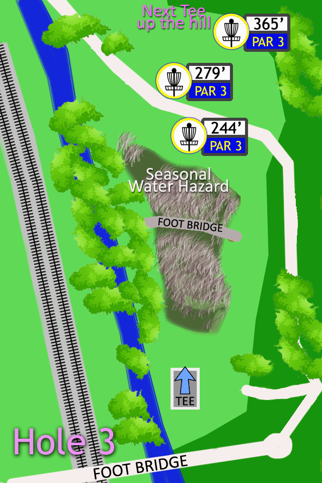
These are just a couple of the ones I've done (Only 16 more to go!) for my home course of Paco Sanchez. Once I got the little icons made - the maps take about 15-30 minutes a piece to make - some longer if they're really complicated. I used google maps and some of the existing maps to get measurements.

My thought is that if people with a little bit of adobe skills (And Adobe Photoshop CS2 is free) could whip up these for the courses you know - then we could add them as a zip file of Gif's to the course reviews on here.

My thought was to try to keep them in standard sizes - these are in 640 x 960 and look good on my HTC Evo 4g. Once they're made I'd probably try to get them resized to a more iPhone friendly size.

It would take a bit of work - but it would be a cool way to give back to the dg community - to promote the sport to people who don't know their way around a course. If

Obviously it would be nice to have some level of standards for sizes of maps and iconography... but at the base level it would be really cool to have the Hole #, the tee box, where the next tee box is, and where the pins are.

I've thought about trying to have 3 maps for each hole - so that there's an easy way to have an accurate map for the basket that's in - but I think it would just lend itself to massive confusion.

Interest? Thoughts? Want to get involved?
 
the maps take about 15-30 minutes a piece to make - some longer if they're really complicated.

I've thought about trying to have 3 maps for each hole

...with tens of thousands of unique holes on this site, you can imagine the amount of work you're proposing.

The problem is finding someone motivated enough to do this. The maps themselves are not useful to the creator, so you have to find someone that has enough desire to spend hours of their own time to create an amenity that will draw maybe a handful of extra players to the course.

More commonly, people will just post a picture of each tee sign in the course photos.

The ones you did look nice and would make good tee signs themselves. Upload them to the course pictures and I'm sure someone will find them helpful.
 
Personally, I'd rather have one big map of the entire course than 18 different ones that I have to flip through, even if I have to pan along it as I play. Trying to figure out single holes that are mostly under 400' isn't that hard.

That and if you make a map on Monday, and changes to a course happen on Tuesday that alter it, the nicest map in the world is going to suddenly suck, and the efforts that went into making it are going to all be for not.
 
Last edited:
...with tens of thousands of unique holes on this site, you can imagine the amount of work you're proposing.

The problem is finding someone motivated enough to do this. The maps themselves are not useful to the creator, so you have to find someone that has enough desire to spend hours of their own time to create an amenity that will draw maybe a handful of extra players to the course.

More commonly, people will just post a picture of each tee sign in the course photos.

Exactly. It's not the work of a few guys, it's more like saying, "I'll do hole 1-9 for this course that I know really well".

It will take an hour or two to knock out 9 holes IF you have some photoshop knowledge. I can put the .psd files online somewhere for any iconography - so it's as easy as dropping that stuff into the right places.

It's asking alot. Is it asking too much? Maybe... but it's winter anyways. High of 12 and snowing today so I'm not playing!
 
Personally, I'd rather have one big map of the entire course than 18 different ones that I have to flip through, even if I have to pan along it as I play. Trying to figure out single holes that are mostly under 400' isn't that hard.

That and if you make a map on Monday, and changes to a course happen on Tuesday that alter it, the nicest map in the world is going to suddenly suck, and the efforts that went into making it are going to be all for not.

I've tried using a big map on my 4" phone screen and was brutal and really meant for a computer monitor. I've tried taking pictures of the map at the start of a course - that's also a losing bet.

this is the map I tried to use on my phone: http://www.dgcoursereview.com/course_files/1459/970b322b.pdf

I rarely see changes (other than baskets moving between the placement options) to our courses. Is that all that common?
 
I'm with scarpfish, I do a ton of traveling to play new courses and a full course map is a whole lot more helpful to me than individual hole layouts. The one you linked is fine for me on an iPhone screen, just takes some zooming and scrolling to figure it out (which is still easier than dealing with 18 separate images that don't give more than a general direction to the next tee IMO). What you're making is really nice for tee signs, but it's not the solution that's likely to be the best for traveling players navigating a course the first time.
 
I know I would use it, I've played plenty of courses that I have just wondered around on.
 
But I do agree with the others, full size map would be best.
 
I rarely see changes (other than baskets moving between the placement options) to our courses. Is that all that common?
Many courses get upgrades such as a second set of tees, or new pin placements. Others lose trees. Some get upgraded from nine holes to eighteen and the original nine holes don't carry the same numbers in the new layout.

Its not that these things happen every day, but they do happen enough to where its a lot easier to redo one big map than redo some degree of 18 smaller ones.

While not quite the same thing, I can count about five courses that I've had to reshoot photos for due to such changes, the old photos being taken maybe only 3-5 years ago.
 
Change Photoshop to MSPaint and .psd to .jpg, and I'm in!
 
It's a wonderful idea.....but impractical.

If you're going to go to that much trouble, print the things and put them on posts at the tees.

Most holes are pretty self-explanatory. The greatest navigation needs are to find #1, and to find the next tee (a large map works better, directional signs work best), and to know which pin placement the basket is in.

The number of places that meet the criteria (enough *s to get your heart pumping, no maps or crummy maps, bad signage, no etc.) is pretty small.

But it's a cool amenity for a given course to offer.
 
Last edited:

I have the free version of Udisc and checked out the pay version info and it didn't seem to have maps by hole. Am I wrong on that?

If the vibe is that hole by hole maps aren't worth the effort - then I'm not going to argue that. I would love to see some level of universality to maps and some trend toward ease of use on mobile devices.

My thought was that the biggest bonus would be that you wouldn't have to scroll around on a big map on a small screen, unsure of where you are in relation to the map. Having just the pertinent data (tee location, pin distance, par #s) for the hole you're on and where the next tee is seemed like a big bonus. Especially if it's easy to read, clear and concise on a small screen.

But like I conceded from the get-go... this would be something that people would have to want enough to make the effort worthwhile. I would love it, but if I'm the minority then that's the way the cookie crumbles.
 
Seems like a lot of work to solve a small problem. I am certainly not going to carry a phone on a disc golf course, but finding your way on a new course is part of the gig. It can be frustrating to wander around looking for hole one or the next hole, but...honestly, I have bigger problems than meandering around the woods. Better tee signs is the ultimate answer.
 
Very simple, even handdrawn course maps handle general course navigation very well. Give me one I can stuff in my pocket, and half-decent tee signs and "next tee" signs, and I'm good.
 
I would love to see some level of universality to maps and some trend toward ease of use on mobile devices.

You realize, of course, that we can't get a universal standard for "par", or system of "next tee" signs. The chances of any universal adoption of a map standard might be deemed fanciful.

Even if it could be done, by the time we got 60,000 or so holes drawn, some technical standards would change and we'd be starting all over.
 
I like the idea a lot. I don't have the technical prowess to help draft maps, but I'd definitely use them if they were available.


______________________________________
 
I wonder if there is a mapping utility that could grab the coordinates of each tee pad from DGCR and guide you around the course easily. Of course, coordinates of individual tees would have to be loaded.....but since we are talking about Smartphones to navigate courses I couldn't help thinking this.

I use the heck out of Google Maps on my smartphone, but know next to nothing about waypoints and how they are generated and used in GPS systems.
 
What would be best on a phone would be an augmented reality display, even with such simple markers as teepads and baskets. Go scout the holes for hazards yourselves, lazy bums.
 
I wonder if there is a mapping utility that could grab the coordinates of each tee pad from DGCR and guide you around the course easily. Of course, coordinates of individual tees would have to be loaded.....but since we are talking about Smartphones to navigate courses I couldn't help thinking this.
I've always fancied some sort of app where you could walk up to a point on a course like a tee pad or pin placement, identify what that is to the app, then mark that point using the phone's GPS feature. Upon completion of marking all of the points on the course, it would show you all of the hole spines. You could then upload it for others to use. Perhaps this already exists?

The problem of course, would be getting everyone on the same page in regard to using the app correctly. Considering how many bad directions, descriptions and photos I see on here, I'm not holding out too much hope on that.
 

Latest posts

Top